


Hi readers.
Did you know now the difference between a land and a sky river? Contrary to the surface rivers, atmospheric rivers are located in the first one to three kilometers of the atmosphere. Also, contrary to the surface rivers which are comparatively shallow, atmospheric river on the average can be 300 miles wide, a mile deep and more than 1,000 miles long. Please note that Indus river is 3180 kilometer long while Yangtze river of China is 6300 kilometer long while its depth is only 800 meters.
Between October 14th and 27th 2017, a long, narrow stream of clouds, storms, and moisture (atmospheric river), stretched corner to corner of the Pacific Ocean for more than a week.
Please don’t confuse sky river with Jet stream which is relatively a narrow band of strong wind instead of moisture in the upper levels up to 35000 feet of the atmosphere. The winds blow from West to East in jet streams, but the flow often shifts to the North and South. Jet streams follow the boundaries between hot and cold air
Such phenomenon can usually be observed during fall and winter in North Pacific which brings heavy rains and snow to the Northwest Pacific and California.
Contrary to this, the phenomenon observed between October 17-24th, 2017 was disbelieving due to its length. The atmospheric rivers with its flow of moisture extended approximately 8,000 kilometers from Japan to Washington and was about two to three times the typical length of an atmospheric river, said Bin Guan: a researcher at the Joint Institute for Regional Earth System Science in collaboration between NASA’s Jet Propulsion Laboratory and the University of California, Los Angeles. What was most mesmerizing about this river were the kind and types of natural colors seen through satellite images (pl. see figure bellow) which showed how skies over the Pacific Ocean appeared on October 14th and 17th as observed by Visible Infrared Radiometer Suit (VIIRS) on the Suomi NPP satellite. Upon pushing by the jet stream winds, the line of clouds started extending Westward from Asia on October 14th, and formed a continuous cloud line stretched all the way to the West coast of North America.
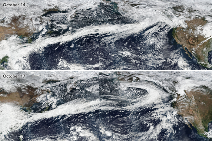
A careful analysis of the VIIRS images taken between October 16th and 18th, 2017 revealed that this Atmospheric River contained a series of waves of extratropical cyclones during various stages of its life cycle progressing along a semi-stationary storm track (A stationary front is similar to a warm front, i.e., warm air is present behind it (to its South) and cool air ahead of it (to its north). However, while a warm front shows movement, a stationary front shows little or no movement as the cooler, more dense air remains intact and does not advance, said Bryan Mundhenk of Colorado State University. For example, a comma-shaped cyclonic feature and a temporary break in the line of clouds can be noticed at the Eastern edge of the October 17 image (pl. see above mentioned figure again).
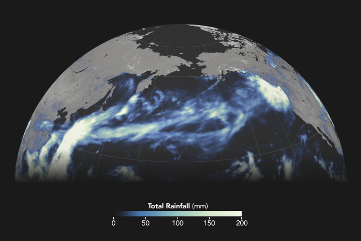
However, the animation (please see below mentioned second figure ) shows rains accumulating in a narrow band across the Pacific between October11th, and October 22nd .
and VIIRS data from LANCE/EOSDIS Rapid Response
Since atmospheric rivers often bring strong winds, they can force moisture up and over mountain ranges and drop a lot of precipitation in the process. In this case, more than four inches of rain fell on the western slopes of the Olympic Mountains (mountain range on the Olympic Peninsula of the Pacific Northwest of the United States) and the Cascade Range (a major mountain range of Western North America, extending from Southern British Columbia through Washington and Oregon to Northern California), while areas to the east of the mountains (in the rain shadow generally saw less than one inch of rain. This Story is posted by Adam Voiland.
What the story by Adam Voiland is telling us?
It tells us that climate change could open up rivers in sky over East Asia
https://www.sciencealert.com/climate-change-could-open-up-rivers-in-the-sky-over-east-asia
It is emphatically clear that as the climate change will have disastrous effects on weather system because it is altering temperatures, rainfall and wind patterns. Influenced by the above-mentioned phenomenon, climate scientists from University of Tsukuba, Japan conducted a study using data collected from 1951 to 2010 and used it in modeling up to the year 2090 assuming an increase in temperature predicted by extreme scenarios of climate change, high-resolution global atmospheric circulation model simulations, and regional climate model downscaling simulations models.
Results revealed that rainfall events in East Asia will be more frequent and more severe in coming decades because the planet is warming up . These rainfall events could be as distresses as those currently playing havoc in Western USA. Climate scientist believes that this disaster could be due to atmospheric rivers: a narrow band of concentrated moisture which can quickly release massive amount of water upon hitting mountain range and could cause disastrous flooding and debris flow. Scientists also believes that as more moisture will be transported through air more precipitation will land on the ground especially of East Asia.
The study further revealed that when it comes to the regions such as Japan, Taiwan, Northeastern China, and the Korean Peninsula, the rainfall could reach record-breaking levels, and much of it will land on the Southwestern slopes of Japanese Alps.
There has been plenty of research into these atmospheric rivers, but how these rivers will change as the climate does? especially when their behavior is determined by topological features as well as movements of warmer and cooler air. For some regions, increased rainfall will be a benefit; for others, it could cause dangerous, life-threatening flooding which shows a link between climate change and increasing frequency of extreme weather events.
The researchers believes that their modeling could also be applied to other regions of the mid-latitudes such as in western North America and Europe, where atmospheric rivers might develop. The interactions between these atmospheric rivers and steep mountains can play a major role in intense precipitation. These regions may also experience more frequent and intense precipitation events as the climate warms. It still remain uncertain, but it is very likely that certain parts of the globe are going to see a lot more rainfall in the coming decades. For more details, please read Geophysical Research Letters at (https://agupubs.onlinelibrary.wiley.com/doi/10.1029/2021GL096030).
Dear readers, Atmospheric rivers (ARs) that reach the complex terrain of High Mountain Asia (HMA) cause significant impacts on millions of people due to their association with extremes precipitation that can cause foods and debris flows affecting populated communities whereas it is not yet clearly understood how ARs reach as far inland as HMA.
Studies indicated dynamical mechanisms associated with the development of ARs that typically affect HMA. Three subtypes of AR events with distinct summary of characteristics were observed during the study for winter and spring months.
The first subtype increases precipitation and Integrated Vapor Transport (IVT) in Western HMA and is associated with a zonally oriented wave train propagating within the westerly jet waveguide like the one that played havoc in Southern China through heavy rainstorm in December 2013.
The second subtype is associated with enhanced Southwesterly IVT, irregular upper-level cyclonic circulation and precipitation in Northwestern HMA.
The third subtype shows irregular precipitation in Eastern HMA and Southwesterly IVT across the Bay of Bengal.
Inter-annual variations in the frequency of HMA ARs and relationships with various teleconnection (a causal connection or correlation between meteorological or other environmental phenomena which occur a long distance apart) patterns show that Western HMA AR subtypes are sensitive to El Niño Southern Oscillation, Arctic Oscillation, and the Siberian High: a massive collection of cold dry air that accumulates in the Northeastern part of Eurasia from September to April. These results indicated irregular characterization of the three types of ARs that reach HMA and reveal the previously unexplored significance of their contribution to winter and spring precipitation.
That’s all for now dear readers. More will be next week about atmospheric rivers of East and South Asia and their possible impact including the diesters of 2010 and 2022 in Pakistan. Till then, Bye


2 Comments
Akram Khalid
January 19, 2023 at 2:11 amVery informative article.
shafqat
January 21, 2023 at 7:12 amThankyou. Please share it