
A re-call
Hi readers, you are now well aware of Atmospheric Rivers (AR): the long narrow bands of moisture that extend from tropics to higher altitudes which can transport 15 times more water than that of the Mississippi.
Introduction
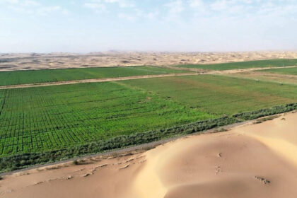
During recent decades, most parts of MENA regions have floods, prolonged droughts, dust storms, heatwaves and wildfires affecting both food and energy security and health sector as well. Not only this, but the entire ecosystem of this region has been affected as marshes in Southern Iraq and Iran are drying up and so does biodiversity reside there.
The questions
Why are these extreme events taking place in this region?
What are the complexities of region’s three dimensional and time-based interaction of various climatic features?
What is the role of summer Indian monsoon?
What is the role of Zagros mountains of Iran (long mountain range in Iran, Northern Iraq, and Southeastern Turkey with a length of 1600 km Iraq, providing natural barrier and boundary between cultural and political entities like that of Mesopotamian, Parthian and Roman empires, Persian and Ottoman empires)?
What is the role of Turkey in regional weather phenomena, such as the Shamal winds (Northwesterly wind blowing over Iraq and the Persian Gulf states)? and
What is the role of Zagros Barrier Jet, ZBJ: A jet on the windward side of a mountain barrier and blowing parallel to the barrier?
To answer these questions, it is important to understand the precipitation, which is the most important among all these factors and so are the Atmospheric rivers (AR) that contribute to regional rainfall. Their impact on Eastern Pacific and Atlantic Oceans is known but not much is known about ARs (13 to 30 in MENA region), and their characteristic and contribution to flooding in the region.
What happened? Why, when and where?
If we could recall, there were two devastating floods in Iraq, Syria and Iran in 2017 and 2019.
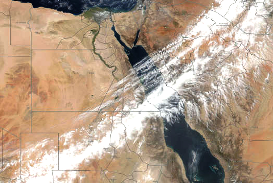
The flood that hit Iran in March 2017, killed 76 people and caused US$2.5 billion of damage. The flood was caused by a 9000 km long atmospheric river originating from tropical Atlantic Ocean, travelled across North Africa before reaching Zagros mountain, forced over higher terrain, cooled and condensed there and poured heavy rain in Iran.
Water transported by this atmospheric river was equivalent to more than 150 times the aggregated flow of the four major land rivers in the region: the Tigris, Euphrates, Karun and the Karkheh. The two days intense rains made rainy season of 2018-19: the wettest in four decades and was a rapid change from 2018: the driest season over the same period. Such sharp and monumental dry-to-wet transitions can increase the chance of landslides.
Similarly, the devastating floods of April 2017 in Northwestern Iran were also caused by AR that brought torrential rainfall and rapid snowmelt over highlands which also brought water for desiccating Urmia lake: the world largest saltwater lake.
One of the unique characteristics of AR mediated floods of 2017 was its facilitation in transporting mineral dust aerosols along their dominant pathways which can impact air quality and cloud formation.
Second distinct feature of MENA region’s AR was their ability to travel long distances over hot and dry deserts retaining its moisture derived primarily from Mediterranean and Red Seas in the region.
The third distinct feature is that contrary to 2019, comparatively low intensity seasonal rainfall in 2017 indicated that heavy flooding can be experienced in both wet and dry years.
Any analogy to what happened in Pakistan in 2010 and 2022?
A Government official Rina Saeed Khan said on September 22nd 2022, that.
“unlike the 2010 floods, this year’s disaster is a result of rain-triggered floods amplified by the La Niña weather pattern (La Nina refers to the periodic cooling of ocean surface temperatures in the central and east-central equatorial Pacific). Typically, La Nina events occur every 3 to 5 years or so, but on occasion can occur over successive years. La Nina represents the cool phase of the El Nino/Southern Oscillation cycle.
Sherry Rehman, Pakistan’s Minister for climate change, said,
“The extent that the disaster is an impact of climate change is not yet known; attribution studies to determine this are currently being carried out with the results expected later this month: September 2022. But it is already evident that climate change was a factor”.
Fahad Saeed, a climate scientist at global think tank Climate Analytics told The Third Pole that 2010 disaster was caused by riverine floods triggered by very heavy rainfall in the mountains of Northern Pakistan in July. Saeed said that the floods travelling down the Indus River from the North to the Arabian Sea provided a considerable lag time in which regions downstream could take evacuation measures.
I don’t have any evidence that glacial melt played a major role as the River Jhelum has normal flows. These were rain-triggered flood and were compounded by flash flooding in some Northern districts, again due to heavy rainfall and cloudbursts (an extreme amount of precipitation in a short period of time, sometimes accompanied by hail and thunder, which is capable of creating flood conditions. Cloudbursts can quickly dump large amounts of water, e.g., 25 mm of precipitation corresponds to 25,000 metric tons per square kilometer)
He further said, that, like in 2010, the El Niño-Southern Oscillation (El Niño is the warm phase of the El Niño–Southern Oscillation and is associated with a band of warm ocean water that develops in the central and East-central equatorial Pacific, including the area off the Pacific coast of South America) this year appears to be in its La Niña phase. This phase has led to higher rainfall in South Asia in the past.
Moetasim Ashfaq, a computational climate scientist at Oak Ridge National Laboratory in the US, confirmed “La Niña, which has persisted for three consecutive years now, likely played a role in the excessive rainfall this year over Pakistan.” He further said, that in “2010 was a single concentration event in July while this year’s disaster is largely due to persistent rainfall in Sindh and Baluchistan”.
What do you think dear reader about these statements?
Here is another study conducted in India titled “Intense precipitation causing floods over Himalayan Region of Northern India where in Indian scientists tried to establish the role of ARs in triggering sudden and extreme precipitation along the Himalayan mountainous regions of North India. They conducted several case studies.
In one of such studies made on August 6th, 2010, they observed Western disturbance (an extratropical storm originating in the Mediterranean region that brings sudden winter rain to the Northern parts of the Indian subcontinent, which extends as East as up to Northern parts of Bangladesh and Southeastern Nepal because upper air cyclonic circulation (swirling motion of winds caused by a low pressure area that pulls in warm and moist air resulting in precipitation) extended up to 4.5 km A.S.l (a function of distance in km from the Keflavik radar that shows the location of precipitation, its type and recent movement) over Northern Pakistan and adjoining J&K. A trough (region of low atmospheric pressure) in mid and upper troposphere prevailing Westward) help augmenting the water vapors and its movement forward.
According to a study reported on the Leh Cloudburst, large-scale tropospheric flow towards South of the Western Himalayas and its cross-sectional analysis suggested that a cloudburst evolved in deep humid layer of flow from the Northwest of Leh region. While the flow from the East and Southeast is relatively cold and dry, plugging of relatively warm and humid air flow from the Northwest triggered instability.
A deep convection close to Western Himalayas over Pakistan was also observed along with a light gray narrow region of water vapors coming from the Arabian Sea towards the mountains of Leh. This flow depicted a 15-20 Kg/m2 of columnar precipitable water (the depth of water in a column of the atmosphere, if all the water in that column was precipitated). This deep humid layer mentioned above is also known as Atmospheric River which brings sudden rains after moving up in the mountains. As a consequence, Northern India received isolated snow and rainfall due to Western disturbances. In the absence of external forces like ARs, such activities cannot be so vigorous. The study thus, identified the role of the ARs in triggering sudden and extreme precipitation along the Himalayan mountainous regions of North India.
Any possibility of such phenomenon in 2010 and 2022 floods in Pakistan?
If an atmospheric rivers with its flow of moisture extended approximately 8,000 kilometers from Japan to Washington pushed by jet stream winds, started extending Westward from Asia and formed continuous cloud line stretched all the way to the West coast of North America and precipitate there, if another 9000 km long atmospheric river originating from tropical Atlantic Ocean, travelled across North Africa before reaching Zagros mountain to precipitate there, why an AR can’t travel from North India to Himalayan region of Pakistan?
Nobody ever thought of this in Pakistan not even what the Atmospheric Rivers are even after I blogged on it on January 5th, 2022.
Lesson learn
Atmospheric rivers can be both hazardous and beneficial. This means it is important to direct research into the context of decision support systems, tailored to the entire region, to minimize adverse impacts and maximize benefits.
That’s all for now dear readers. More next week. Till then, take care, Bye